
A Stone’s Throw: A Series on Race and Place in America

Graphic courtesy Raisz Maps.
Land patterns from the Atlantic coast westward provide condensed narratives of Earth and human histories inseparably linked, histories of ideas as well as actions, histories of change. Forest, field, and urban patchworks of the Northeast give way west of the Appalachian Mountains to agricultural fields and large meandering rivers that drain the midcontinent to the Gulf of Mexico. Beyond the Mississippi River, summer’s verdant lowland gradually but noticeably becomes the beige and brown Great Plains, a semi-arid land broken by green pivot-circles and other signs of irrigated agriculture.
The plains and prairies have a long history of human engagement—of transitions, of migration and movement, of dispossession and removal. Few ecosystems on Earth have been changed as rapidly or as extensively as these grasslands, from diverse Native American lifeways to Euro-America’s wholesale agricultural transformation over the last century and a half. How these latter settlers saw and imagined the midcontinent and their relation to it over time is a vital piece of this country’s environmental history. Reading this land and its fragmented memory in stone and sand, and in remnant grasses, also gives a clearer sense of what Jacquetta Hawkes called the “continued presence of the past.”
In the language and theories of science, the midcontinent between the Appalachian and Rocky Mountains is considered a stable interior platform, a region that unlike the eastern and western edges of the continent has not experienced cataclysmic mountain building within hundreds of millions of years. Evidence of this stability comes from the region’s overall flatness, both at the surface and replayed at depth by horizontal to gently warped sediments and sedimentary rocks. These sands and muds, and more ancient sandstones, limestones, and mudstones (of Paleozoic, Mesozoic, and Cenozoic ages) record long-vanished inland seas, the evolution and demise of dinosaurs and other extinct creatures, the decay and erosion of mountains to the east and west, and the recent work of ice-age glaciation.
Ecologically the midcontinent is, or was, largely grasslands. The 100th meridian of longitude, which cuts through the Dakotas, Nebraska, and Kansas, and then across western Oklahoma and Texas, is a significant geographic and ecologic border. Walter Prescott Webb referred to it as a cultural or “institutional fault.” This meridian very roughly coincides with the 20-inch rainfall line. To the west of it, with less annual precipitation on average, the semi-arid Great Plains are subject to drought. Wooded areas of any real size become largely confined to local pockets and riparian corridors along rivers like the Platte or Arkansas. Fan-like dendritic patterns of countless small but erosive, ephemeral streams stand out as breaks and badlands. The 100th meridian marks the approximate boundary between what was once the prairie’s vast sea of tall grasses and the short grasses of the plains, between big bluestem, Indian grass, switchgrass, and prairie cordgrass to the east and buffalo and blue grama grasses to the west. It also coincides with the 2,000-foot elevation contour, often a low, east-facing escarpment or “break in plains” that is the farthest reach of eroded debris washed from the Rocky Mountains. Here the eastward sloping Great Plains meet the Central Lowlands, a region of Great Lakes and large rivers emptying into the Mississippi. These patterns can be seen from the sky with Erwin Raisz’s map as a guide.
To most Euro-American settlers before the mid-19th century the continent’s grasslands were strange and often threatening. These people’s agrarian lifeways and visual habits preferred a more familiar humid and forested (or recently deforested) east. To the west of the Appalachian Mountains lay woodland-bounded open areas that were much larger than the clearings, meadows, or native fields found to the east. The French term “prairie,” meaning meadow land, was first applied to the grasslands of the Mississippi Valley and then extended more broadly to large open expanses across the Central Lowlands. Lewis and Clark used “prairie” as they followed the Missouri River toward its western source until, in 1805, the patches of open land grew into seemingly limitless treeless expanses. Then they wrote of “vast” and “extensive” and “great plains.” Earlier French trappers referred to nearly impassable eroded drylands that were cut by ridges and ravines as “mauvaises terres,” which translated into English as “badlands.”

Photo by Lauret Savoy.
George Stewart notes in Names on the Land that many midcontinent place-names on maps and in the journals of European explorers and trappers are translations, transliterations, clippings, or reshapings of words drawn from the languages of Native American peoples encountered. Rivers, landscape features, and specific areas were often named for particular native groups living there, or were modified versions of indigenous place-names. Messouri, Ouchage, Maha (or Omaha), and Kansa are but a few such names that French explorers placed on major rivers to note the presence of those people. One braided river that crosses the plains was called Ni-bthaska in one native language, “ni” for river and “bthaska” as a reference to its spreading flatness. French explorers in the 1700s translated this name to Riviere Plate, but spelled it Platte. The Platte River, as the named survived, became a prominent lifeline of 19th-century migration routes to the West—and the Platte River Road, a grand corridor for the trails to Oregon and California. From Ni-bthaska came the name of one state through which the river flows.
The midcontinent prairies and plains have been given many identities: the land where sky begins, land of the buffalo, the Great American Desert, the great prairie wilderness, the sea of grass, Indian Territory, the frontier, the West, the Midwest, the wheat belt, the Dust Bowl, the garden or breadbasket of the world. Each one threads together narratives of how these lands were encountered and understood. The stories of finding “desert” are among the most revealing.
We can trace the evolution of “desert” as a descriptor of any wild, uninhabited and uncultivated tract or desolate region to a term referring to an arid barren area. In Judeo-Christian tradition, “desert” carried the original meaning of wilderness or deserted area, and in the world described by the Bible, desert was associated with arid lands. Historian Patricia Limerick notes that as the word’s use evolved in Europe, its association with emptiness remained. Early English colonists commonly described the Atlantic seaboard as deserted. Captain John Smith declared of Virginia in 1608 “the most of this Country though Desert, yet exceeding fertile,” and in 1693 Puritan leader Cotton Mather wrote of their voluntary “exile” to New England, “a Squalid, horrid, AmericanDesart.
The connection with aridity was partly restored by the 19th century as “desert” was applied to lands beyond the Appalachian Mountains, first to the sub-humid and semi-arid grasslands of the midcontinent, and later to the true drylands farther west. But associating these lands with vacancy or emptiness was always a mistake because neither the East coast nor inland regions was uninhabited or unused. By year-long occupation, and seasonal presence and mobility, tribal peoples fully inhabited and invested themselves in the land long before the arrival of Europeans.
The desertness of the western plains was noted by members of the Spanish Entrada in the 1500s and by members of the 1804-06 Lewis and Clark expedition. Yet it was the reports from later government-sponsored explorations across the central and southern plains led by Zebulon Pike (in 1806-07) and Stephen Long (in 1819-20) that set the terms by which Anglo-Americans viewed grasslands west of the Mississippi River. They placed the “Great American Desert” into an eastern public consciousness—a land Long called “almost wholly unfit for cultivation, and of course uninhabitable by a people depending upon agriculture for their subsistence.” Such ironic words would shape a great deal to come.
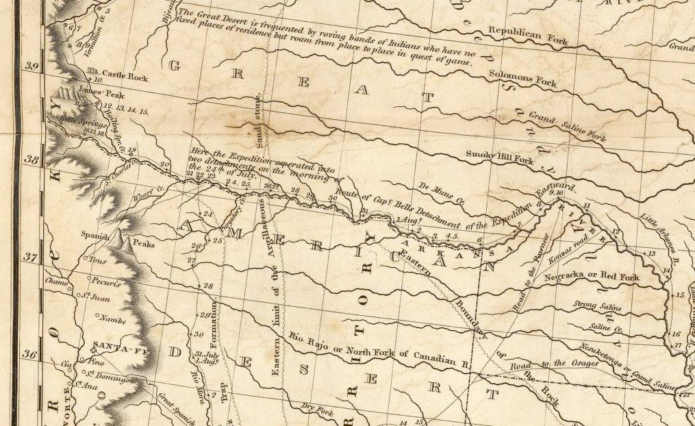
Graphic courtesy GISforHistory.com and University of Illinois, Chicago.
I would not think I had done my country justice did I not give birth to what few lights my examination of those internal deserts has enabled me to acquire. In that vast country of which I speak, we find the soil generally dry and sandy, with gravel…. But here a barren soil, parched and dried up for eight months in the year, presents neither moisture nor nutrition sufficient to nourish the timber. These vast plains… may become in time as celebrated as the sandy deserts of Africa; for I saw in my route, in various places, tracts of many leagues where the wind had thrown up the sand in all the fanciful form of the ocean’s rolling wave, and on which not a speck of vegetable matter existed.
But from these immense prairies may arise one great advantage to the United States, viz.: The restriction of our population to some certain limits, and thereby a continuation of the Union. Our citizens being so prone to rambling and extending themselves on the frontiers will, through necessity, be constrained to limit their extent on the west to the borders of the Missouri and Mississippi, while they leave the prairies incapable of cultivation to the wandering and uncivilized aborigines of the country.
— Zebulon Pike, The Expeditions of Zebulon Montgomery Pike
Stephen Long agreed with Pike, and added that the region “may prove of infinite importance to the United States” by also acting as a western barrier to “secure us against the machinations or incursions of an enemy that might otherwise be disposed to annoy us in that part of our frontier.”
Neither Pike nor Long crossed the Rocky Mountains and encountered true aridity. Still their ideas of the western midcontinent as barren desolation affected at least to mid-century the courses of later exploratory surveys, of agricultural settlement, and of the displacement and removal of many native peoples to the trans-Mississippi West. Surface water was scarce on much of the plains and at that time no real means of pumping groundwater for irrigation existed. Wood for building and fuel was limited or non-existent beyond watercourses, as were communication or transportation networks. Although not true desert as now understood, the treeless plains were at odds with conventional Euro-American notions of landscape, such as the practice of judging the land’s fertility by the types of trees growing. The plains did for a time set limits to movement and settlement.
The Great American Desert was popularized beyond government reports by traveler’s accounts, newspaper articles, and literature of the day. Alexis de Tocqueville wrote of it in Democracy in America in the 1830s. Although he never visited the region he declared with certainty that beyond the Mississippi River “the sparser the vegetation and the poorer becomes the soil, and everything wilts or dies.” As if this weren’t enough Tocqueville added that “the soil is punctured in a thousand places by primitive rocks sticking out here and there like the bones of a skeleton when sinew and flesh have perished.”
Charles Preuss, cartographer on several of John C. Frémont’s expeditions, did visit the region and found it lacking. His 1842 diary grumbles: “Eternal prairie and grass, with occasional groups of trees. Frémont prefers this to every other landscape. To me it is as if someone would prefer a book with blank pages to a good story.”
The idea of the Great American Desert as a barrier lost a bit of its power when transcontinental travel to the Pacific coast increased beginning in the 1830s and 1840s. On the numerous overland wagon routes (like the Oregon, California, Santa Fe, and Southern trails), explorers and emigrants finally experienced true arid lands farther west. After the Civil War the agricultural front pushed westward onto the Great Plains as settlement moved up the valleys of the Platte and other rivers. What once was an inhospitable land to be passed through quickly had become a destination. Henry Nash Smith, who in Virgin Land wrote of the power of images and ideas of the West, posited that by the late 19th century the westward extending “myth of the garden,” of an agricultural transformation of the frontier, contended with and in many ways reshaped the myth of the Great American Desert. It became a commonly held belief of many, scientists as well as settlers, that crop cultivation and tree planting could modify climate, and thus ameliorate the harsh plains environment.

Photos by Lauret Savoy.
West of the Rocky Mountains lie what Patricia Limerick has called the deserts of actuality rather than deserts of myth. There, too, language failed in the process of naming as English words did not exist to describe many arid landscape features. Terms that we now use without thinking (such as canyon, mesa, arroyo, or playa) were adopted from Spanish and other languages.
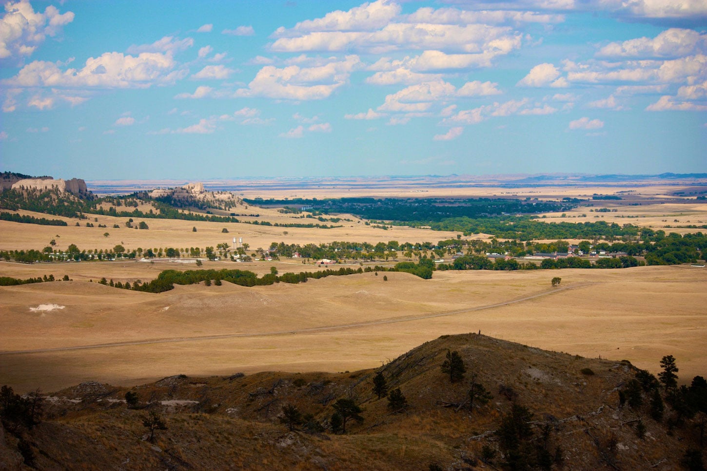
On the high western plains, as well as in the Southwest, dryness and erosion conspired to expose the land’s anatomy bare of the vegetative clothing found in the humid east. In Man in the Landscape human ecologist Paul Shepard considered the evocative power of such terrain in written responses of westward-bound travelers to erosional remnants they saw along the Oregon Trail. Isolated spires, buttes, and escarpments along the Platte River became structures of ghostly or ruined architecture in journals of overland trappers, soldiers, and westering emigrants. Observers discovered city buildings, lighthouses, forts, spires, streets, and castles—often in ruins. Many references were made to rocks given names like Chimney, Steamboat, Table, Jail, and Courthouse.
Encamped to-day near what I shall call the Old Castle, which is a great natural curiosity. It is situated upon the south side of the Platte, on a plain, some miles distant from any elevated land…. It has… all the appearance of an old enormous building, somewhat dilapidated; but still you see the walls standing, the roof, the turrets, embrasures, the dome, and almost the very windows; and the guard-houses, large, and standing some rods in front of the main building. You unconsciously look around for the enclosures, but they are all swept away by the lapse of time—for the inhabitants, but they have disappeared; all is silent and solitary. Although you correct your imagination, and call to remembrance that you are beholding the work of nature, yet, before you are aware, the illusion takes you again, and again your curiosity is excited to know who built this fabric, and what has become of the bygone generations.
— Reverend Samuel Parker, along the North Platte River in 1835
Travelers also pondered the materials composing the carved landscapes and the passage of time on an unimaginable scale.

Photos by Lauret Savoy.
Yet how often do we think about the past in our present? What is necessary to grasp the power of deeply rooted values and ideas on how we think and tell stories about Earth, and then attempt to live by them? Perhaps geographies of the mind are as crucial to understanding the meaning of the American Earth in human experience as the land itself and our marks upon it.
Header photo of Western Nebraska by bcbrewster, courtesy Pixabay.